5 Amazing Weather Forecast Technologies Being Used Today
Predicting weather patterns is an important scientific observational task, more so with today’s climate change impact on a global scale. Today, innovations in technology allow research centers to gather data and process forecast models in real-time for a particular region. Hundreds of these systems and stations are deployed across key strategic measurement locations to get near-accurate readings. Here are the five most crucial and innovative technologies that can be integrated to provide a reliable weather forecast.
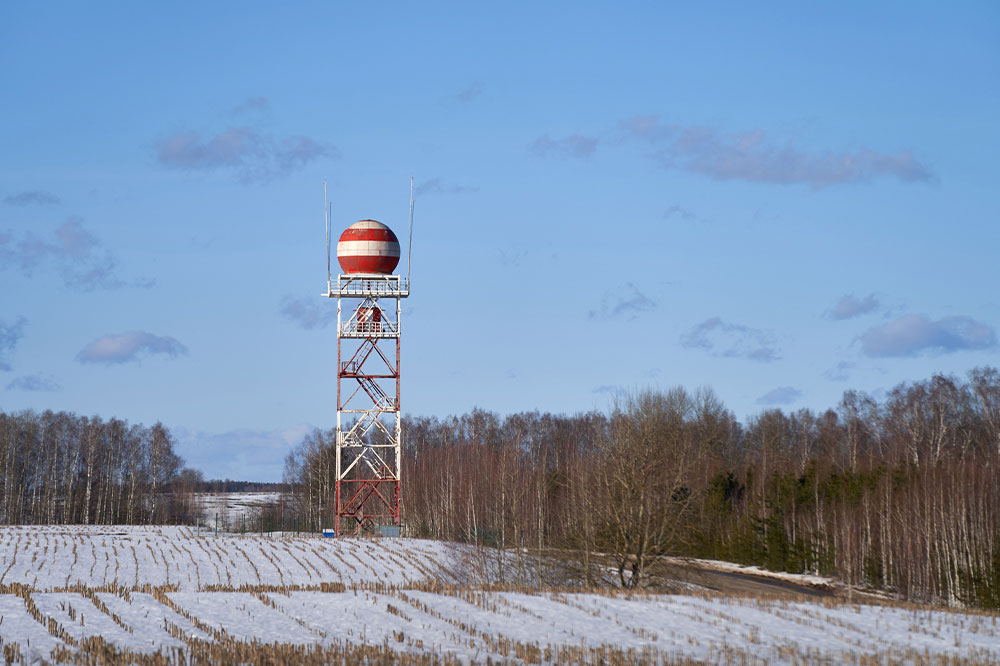
Doppler radars
Radars work with a simple principle using energy waves to bounce off objects in the direction it travels. When aimed at the atmosphere, the energy waves bounce off and scatter in several directions. The radar antenna captures this pattern to record and mark a specific observation. Today, with technological innovations, engineers have designed elaborate doppler radar systems that go one step further in their discovery. Where radio antennas could only map the object’s position, doppler radars could also map out simultaneous movements of the object bouncing off the waves. The shift in energy pulse sent is mapped out in real-time. If the object were nearer, the shift would be recorded with a higher frequency. And the further the object, the lower the frequency recorded back at the receiving station. Doppler radars are very useful in monitoring storm systems across the coast and inland, with the country boasting over 159 radar towers monitoring every weather shift.
Radiosondes
Radiosondes were developed to measure and provide weather forecasts at a particular location using a simple helium or hydrogen balloon. Multiple sensors would be attached to this floatation device, and meteorologists would release these devices into the atmosphere. These sensors on board would be powered by a battery pack enabling them to send signals to the ground receiver. Radiosondes are excellent devices for measuring wind speed and wind direction. A single flight can easily last for a couple of hours, with the device capable of ascending to 115,000 feet or 35,0000 meters, drifting over 125 miles on average. In addition to being efficient, light, and highly accurate, the device is also designed to withstand massive temperature drops of up to -130° F as the balloon gets higher and higher. The National Weather Service in the country releases over 75,000 balloons attached to these devices each year to get the best reading for accurate weather forecasts.
Automated Surface Observing Systems (ASOS)
It is not possible to rely solely on radar and radiosondes to give accurate reports of changing weather. That is why ground-automated surface observing systems are installed at select locations to compare and compile additional data received for better accuracy. ASOS is a joint effort between the National Weather Service, the Federal Aviation Association, and the Department of Defense. ASOS is one of the most advanced monitoring systems that can predict several parameters for weather forecasts. The system can forecast cloud height and cluster up to 12,000 feet, provide basic weather status about rain, snow, and hailstorms, and identify any obstructions like fog, haze, or dust. In addition, ASOS can also give near-accurate readings for wind direction, wind speed, wind cluster, sea level pressure, altimeter readings, and precipitation accumulation for a complete weather forecast. These systems are also operational 24/7 and can be synchronized to multiple receiving stations for data recording and retrieval.
Advanced Weather Interactive Processing System (AWIPS)
All the raw data collected using doppler radars, radiosondes, and observing systems needs a central console to process the information. AWIPS comprises servers, display systems, and telecommunications systems integrated with a central console. This mega computer ingests thousands of gigabytes of updated data using a real-time satellite communications uplink. Ultimately, all the raw information is processed through templates and algorithms used for creating weather forecast models. It can combine different types of imagery taken from the ground, satellites, and weather system grids across the globe. One of the biggest advantages of an AWIPS system is its capability to integrate multiple networks on the same server to enable seamless information sharing. This enables multiple AWIPS stations across the country to work together and predict near-accurate weather forecasts.
Weather satellites
With the invention of space probe launches, weather satellites became the next best device to place in orbit to monitor all shifts in weather. The satellites orbit the globe at a fixed height and travel at high speeds while taking images from a higher altitude, giving a much clearer picture. The satellites orbit back to the same spot after completing a circuit allowing it to take multiple readings to be pinged back to ASOS and AWIPS monitoring systems back on the ground. Scientists and meteorologists can analyze real-time imagery, atmospheric soundings, and even moisture data focusing on a specific location. The data is updated with every orbit; satellites only take about 30 minutes to circumnavigate the globe, moving at the height of roughly 22,000 miles above the equator. The readings can be compared with previous findings to create feasible weather forecast models.
Combining these technologies allows meteorologists and weather research stations across the globe to monitor the minutest of fluctuations to be prepared for any impending catastrophic shifts. Today, these systems can sound off warnings days or weeks in advance by predicting the path of a cyclone, tornado, storm, or any major weather shift. This enables the government to initiate safe relocation and rescue operations for locations that are in the way of danger.

